CTUIR Fisheries Habitat Program Reports & Data
View and download relevant reports and data for the CTUIR Fisheries Habitat program.
Project Files
| Title | File | Description |
|---|---|---|
| 2008 Columbia Basin Fish Accords Memorandum of Agreement between the Three Treaty Tribes and FCRPS Action Agencies | 2008_CBfishaccords_MOA.pdf | The Bonneville Power Administration (BPA), the U.S. Army Corps of Engineers (Corps) and the U.S. Bureau of Reclamation (Reclamation)( the "Action Agencies") and the Confederated Tribes of the Warm Springs Reservation of Oregon, the Confederated Tribes of the Umatilla Indian Reservation, the Confederated Tribes and Bands of the Yakama Nation, and the Columbia River Inter-Tribal Fish Commission (CRITFC) ("the Tribes" or "the Treaty Tribes") (collectively "the Parties") have developed this Memorandum of Agreement ("Agreement" or "MOA") through good faith negotiations. This Agreement addresses direct and indirect effects of construction, inundation, operation and maintenance of the Federal Columbia River Power System and Reclamation's Upper Snake River Projects, on fish resources of the Columbia River Basin. |
| Aligning environmental management with ecosystem resilience: a First Foods example from the Confederated Tribes of the Umatilla Indian Reservation | Queampts_FirstFoods_2018.pdf | The concept of "reciprocity" between humans and other biota arises from the creation belief of the Confederated Tribes of the Umatilla Indian Reservation (CTUIR). The concept acknowledges a moral and practical obligation for humans and biota to care for and sustain one another, and arises from human gratitude and reverence for the contributions and sacrifices made by other biota to sustain human kind. Reciprocity has become a powerful organizing principle for the CTUIR Department of Natural Resources, fostering continuity across the actions and policies of environmental management programs at the CTUIR. Moreover, reciprocity is the foundation of the CTUIR "First Foods" management approach. We describe the cultural significance of First Foods, the First Foods management approach, a resulting management vision for resilient and functional river ecosystems, and subsequent shifts in management goals and planning among tribal environmental staff during the first decade of managing for First Foods. In presenting this management approach, we highlight how reciprocity has helped align human values and management goals with ecosystem resilience, yielding management decisions that benefit individuals and communities, indigenous and nonindigenous, as well as human and nonhuman. We further describe the broader applicability of reciprocity-based approaches to natural resource management. |
| CTUIR Fisheries Habitat Program Strategy | CTUIR Fisheries Habitat Program Strategy.pdf | The Fisheries Habitat Program addresses channel and floodplain function and aquatic habitat deficiencies through a systematic, holistic watershed planning approach termed the Riverine Ecosystem Planning Approach |
| First Foods Upland Vision | CTUIR DNR Upland Vision April2019.pdf | This document outlines a vision for desired characteristics of upland ecosystems that will facilitate the production of First Foods and serve as a foundation for natural resource management and restoration activities to ensure healthy, resilient and dynamic upland ecosystems. |
| Physical Habitat Monitoring Strategy (PHAMS) for Reach-Scale Restoration Effectiveness Monitoring | PHAMS_EffectivenessMonitoringApproach.pdf | Habitat restoration efforts by the Confederated Tribes of the Umatilla Indian Reservation (CTUIR) have shifted from the site scale (1-10 meters) to the reach scale (100-1,000 meters). This shift was in response to the growing scientific emphasis on process-based restoration and to support from the 2007 Accords Agreement with the Bonneville Power Administration. With the increased size of restoration projects, the CTUIR and other agencies are in need of applicable monitoring methods for assessing large-scale changes in river and floodplain habitats following restoration. The goal of the Physical Habitat Monitoring Strategy is to outline methods that are useful for capturing reach-scale changes in surface and groundwater hydrology, geomorphology, hydrologic connectivity, and riparian vegetation at restoration projects. The Physical Habitat Monitoring Strategy aims to avoid duplication with existing regional effectiveness monitoring protocols by identifying complimentary reach-scale metrics and methods that may improve the ability of CTUIR and others to detect instream and riparian changes at large restoration projects. (Jones et. al. 2015) |
| The Umatilla River Vision | TheUmatillaRiverVision_JonesEtAl2008.pdf | The Umatilla basin includes a healthy river capable of providing First Foods that sustain the continuity of the Tribe's culture. This vision requires a river that is dynamic, and shaped not only by physical and biological processes, but the interactions and interconnections between those processes. (Jones et. al. 2008) |
Image Files
| Title | File | Description |
|---|---|---|
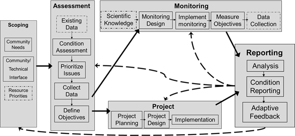
| CTUIR Riverine Ecosystem Planning Approach Diagram |
|
The Fisheries Habitat Program addresses passage, channel and floodplain function and aquatic habitat deficiencies through a systematic, holistic planning approach termed the Riverine Ecosystem Planning Approach. |
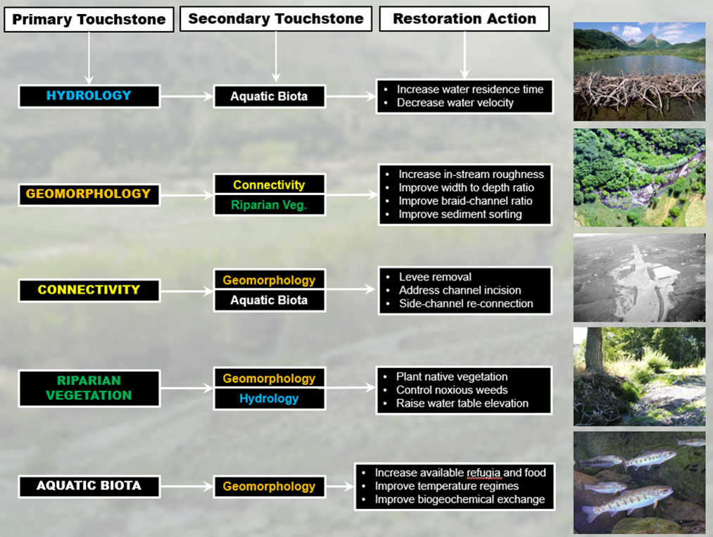
| Incorporating CTUIR River Vision into the Fisheries Habitat Program approach |
|
Diagram of the incorporation of the CTUIR River Vision into the Fisheries Habitat Program approach. |
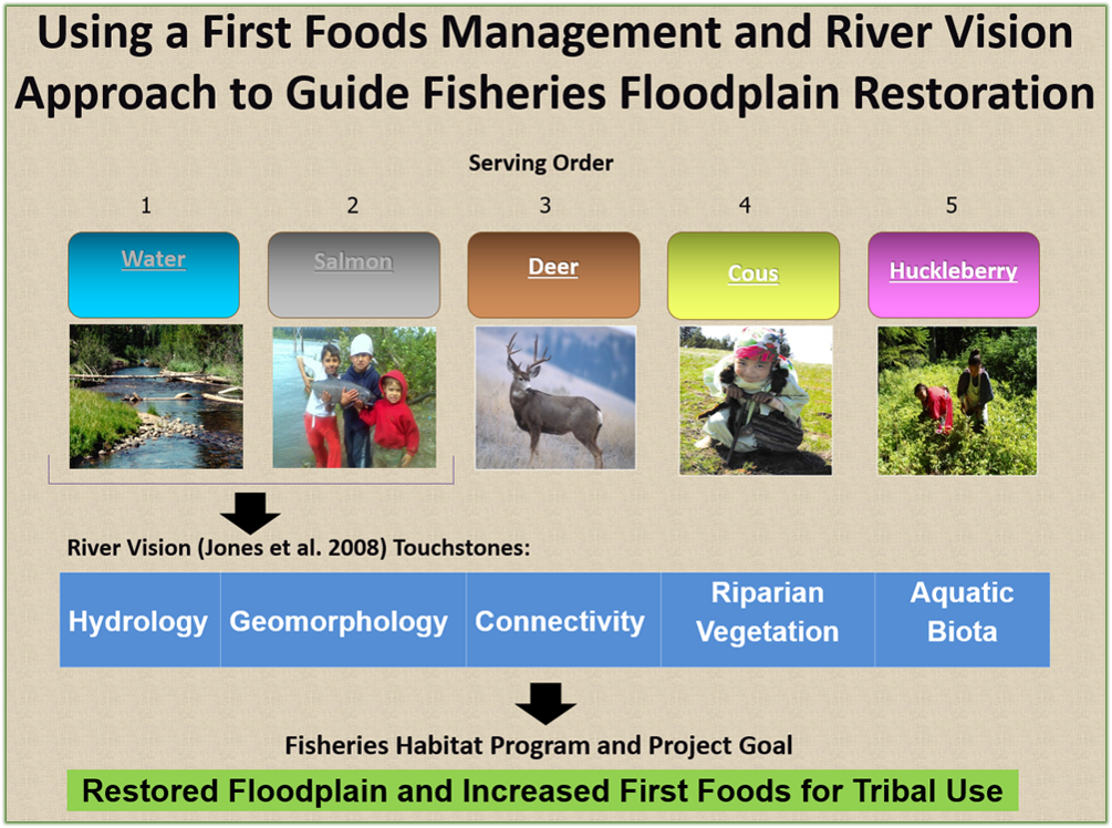
| Using a First Foods Management and River Vision Approach to Guide Fisheries Floodplain Restoration |
|
Diagram outlining a River Vision guided Fisheries Habitat Program that supports floodplain restoration and increased First Foods for Tribal use. |
Individual Subbasin Project Reports & Data
View and download relevant reports and data for each of the fisheries habitat subbasin projects.
Walla Walla Subbasin Fish Habitat Enhancement Project
NF John Day Habitat Improvement Project
Umatilla Subbasin Fish Habitat Restoration
Grande Ronde Subbasin Fish Habitat Restoration
Tucannon River Fish Habitat Restoration Project
Assessments and Action Plans
Below is a list of the Assessment and Actions plans in each of the CTUIR Subbasins. Click on the Restoration Plan title to see more information about the assessment project or open the relevant pdf documents and links listed.
Walla Walla River Basin
- Walla Walla Subbasin Plan 2004
- Snake River Salmon Recovery Plan for SE Washington 2011.pdf
- Snake River Salmon Recovery Region Provisional 3-5 Year Work Plan.pdf
Touchet Restoration Prioritization Plan
- Touchet Geomorphic Assessment and Restoration Prioritization Plan 2011.pdf
- Touchet Geomorphic Assessment and Restoration Prioritization Plan 2020.pdf
- Appendix A- Project Area and Reach Overview.pdf
- Appendix B- Viable Salmonid Population.pdf
- Appendix C- Hydrologic Analysis Methods and Results.pdf
- Appendix D- Hydraulic Modeling.pdf
- Appendix E- Floodplain Connectivity Analysis.pdf
- Appendix F- Channel Complexity Analysis.pdf
- Appendix G- Excess Transport Capacity Analysis.pdf
- Appendix H- Webmap Overview.pdf
- Appendix I-Prioritized Reaches.pdf
- Appendix J- Reaches Outside Prioritization.pdf
Lower Mill Creek Habitat and Passage Assessment and Strategic Action Plan
Upper Walla Walla Assessment and Strategic Action Plan
Lower Walla Walla River Geomorphic Assessment and Action Plan
Couse Creek Assessment
John Day River Basin
John Day Basin Partnership Strategic Action Plan
- John Day Basin Partnership Strategic Action Plan 2018.pdf
- John Day Basin Partnership Operations Manual 2016.pdf
Desolation Creek Geomorphic Assessment and Action Plan
- Desolation Creek Geomorphic Assessment and Action Plan 2017.pdf
- Desolation Creek Geomorphic Assessment and Action Plan 2017- Statement of Goals and Objectives.pdf
Camas Creek Watershed Assessment
- Camas Creek Watershed Assessment 2003.pdf
- Camas Creek Geomorphic Assessment 2017.pdf
- Camas Creek CTUIR Brief.pdf
Fox Creek Restoration Plan
Umatilla River Basin
Birch Creek Assessment and Action Plan
- Birch Creek Assessment and Action Plan 2017 Report.pdf
- Birch Creek Assessment and Action Plan 2017 Appendices.pdf
Meacham Creek Assessment
- Meacham Creek Climate Change Risk Assessment 2016.pdf
- Meacham Creek Watershed Assessment and Action Plan 2003.pdf
- Meacham Creek Watershed Assessment and Action Plan 2003-summary.pdf
Mainstem Umatilla Assessment and Strategic Action Plan
- Umatilla River Assessment and Action Plan Executive Summary 2025
- Umatilla River Assessment 2023
- Umatilla River Assessment Technical Appendices 2023
- Umatilla River Action Plan 2025
- Umatilla River Action Plan Appendices 2025
Grande Ronde River Basin
- Grande Ronde Subbasin Plan 2004
- Atlas Implementation Guidelines- Catherine Creek and Upper Grande Ronde River.pdf
- Catherine Creek and Upper Grande Ronde River Atlas Restoration Prioritization Framework: User’s Manual.pdf
Catherine Creek Tributary Assessment
Upper Grande Ronde Tributary Assessment
Tucannon River Basin
- Tucannon Subbasin Plan 2004
- Snake River Salmon Recovery Plan for SE Washington 2011.pdf
- Snake River Salmon Recovery Region Provisional 3-5 Year Work Plan.pdf
Tucannon Restoration Prioritization Plan
- Tucannon River Geomorphic Assessment and Habitat Restoration Study 2011.pdf
- Tucannon Basin Habitat Restoration Geomorphic Assessment and Restoration Prioritization 2021 and Appendices A-L.pdf
- Appendix A-Project Area Overview.pdf
- Appendix B-Viable Salmonid Population.pdf
- Appendix C- Hydrologic Analysis Methods and Results.pdf
- Appendix D- Topographic Data Summary.pdf
- Appendix E- Hydraulic Modeling.pdf
- Appendix F- Connectivity Analysis.pdf
- Appendix G- Channel Complexity Analysis.pdf
- Appendix H- Excess Transport Capacity Analysis.pdf
- Appendix I- Web Map.pdf
- Appendix J- Project Area Cut Sheets.pdf
- Appendix J1- Treated Project Areas.pdf
- Appendix J2- Untreated Project Areas.pdf
- Appendix K- Riparian Vegetation Analysis.pdf
- Appendix L- Gravel Augmentation Plan.pdf